
Portal:Andes
The Andes Portal

The Andes (/ˈændiːz/ AN-deez), Andes Mountains or Andean Mountain Range (Spanish: Cordillera de los Andes; Quechua: Anti) are the longest continental mountain range in the world, forming a continuous highland along the western edge of South America. The range is 8,900 km (5,530 mi) long and 200 to 700 km (124 to 435 mi) wide (widest between 18°S and 20°S latitude) and has an average height of about 4,000 m (13,123 ft). The Andes extend from South to North through seven South American countries.: Argentina, Chile, Bolivia, Peru, Ecuador, Colombia and western Venezuela.
Along their length, the Andes are split into several ranges, separated by intermediate depressions. The Andes are the location of several high plateaus—some of which host major cities such as Quito, Bogotá, Cali, Arequipa, Medellín, Bucaramanga, Sucre, Mérida, El Alto and La Paz. The Altiplano Plateau is the world's second-highest after the Tibetan Plateau. These ranges are in turn grouped into three major divisions based on climate: the Tropical Andes, the Dry Andes, and the Wet Andes.
The Andes Mountains are the highest mountain range outside Asia. The range’s highest peak, Argentina's Aconcagua, rises to an elevation of about 6,961 m (22,838 ft) above sea level. The peak of Chimborazo in the Ecuadorian Andes is farther from the Earth's center than any other location on the Earth's surface, due to the equatorial bulge resulting from the Earth's rotation. The world's highest volcanoes are in the Andes, including Ojos del Salado on the Chile-Argentina border, which rises to 6,893 m (22,615 ft). (Full article...)
Selected articles
-


Tata Sabaya is a 5,430-metre (17,810 ft) high volcano in Bolivia. It is part of the Central Volcanic Zone, one of several volcanic belts in the Andes which are separated by gaps without volcanic activity. This section of the Andes was volcanically active since the Jurassic, with an episode of strong ignimbritic volcanism occurring during the Miocene. Tata Sabaya lies in a thinly populated region north of the Salar de Coipasa salt pan.
Volcanic activity at Tata Sabaya and elsewhere in the Central Volcanic Zone is the consequence of the subduction of the Nazca Plate beneath the South America Plate. The volcano has developed along a lineament that separates older crust north of the lineament from younger crust in the south, and the edifice has been formed by andesitic rocks. (Full article...) -
Pumasillo (possibly from Quechua puma cougar, puma, sillu claw, "puma claw") is a mountain in the Vilcabamba mountain range in the Andes of Peru, about 5,991 m (19,656 ft) high'. Pumasillo or Sacsarayoc also refers to the whole massif. It includes the peaks Pumasillo, Sacsarayoc and Lasunayoc. It is located in the Cusco Region, La Convención Province. Its slopes are within the administrative boundaries of the Peruvian city of Santa Teresa. ('Full article...) -
Salcantay, Salkantay or Sallqantay (in Quechua) is the highest peak in the Vilcabamba mountain range, part of the Peruvian Andes. It is located in the Cusco Region, about 60 km (40 mi) west-northwest of the city of Cusco. It is the 38th-highest peak in the Andes and the twelfth-highest in Peru. However, as a range highpoint in deeply incised terrain, it is the second most topographically prominent peak in the country, after Huascarán.
Salcantay's proximity to Machu Picchu makes trekking around it an alternative to the oversubscribed Inca Trail; this is known as the Salkantay trek. (Full article...) -
Lanín is an ice-clad, cone-shaped stratovolcano on the border of Argentina and Chile. It forms part of two national parks: Lanín in Argentina and Villarrica in Chile. As a part of the flag and anthem of the Argentine province of Neuquén, it serves as a symbol for the region. Although the date of its last eruption is not known, it is estimated to have occurred within the last 10,000 years. Following the 1906 Valparaíso earthquake a local newspaper reported the volcano to have erupted, but a work published in 1917 by Karl Sapper disputed this.
The ascent is regulated by the management of Argentine National Parks and the Argentine National Gendarmerie and is technically relatively simple but has a much higher level of exposure than the neighbouring volcanoes. The nearest towns, usually employed as a base for climbers, are Pucón in Chile and Junín de los Andes in Argentina. (Full article...) -
Pomerape is a stratovolcano lying on the border of northern Chile and Bolivia (Oruro Department, Sajama Province, Curahuara de Carangas Municipality). It is part of the Payachata complex of volcanoes, together with Parinacota Volcano to the south. The name "Payachata" means "twins" and refers to their appearance. It hosts glaciers down to elevations of 5,300–5,800 metres (17,400–19,000 ft), lower on the northern slope.
Pomerape is a complex of lava domes, accompanied by lava flows which were emplaced atop of the domes. It was active about 200,000 years ago. The lava domes formed first and were later buried by the actual volcanic cone, which unlike the rhyolitic-dacitic domes is formed by hornblende andesite. The "Chungará Andesites" and lava dome complex of Parinacota were laid down at this time. Pomerape is associated with an adventive vent that has erupted mafic magmas. The main cone was last active 106,000 +- 7,000 years ago, the adventive vent is dated to 205,000 ± 24,000 years ago. (Full article...) -
The Pico Pan de Azúcar, at 4680 meters above sea level, is the ninth highest mountain of Venezuela, and the third highest of the Sierra de la Culata range in the Mérida State. Its name, which translates as "Bread of Sugar", is due to the sandy slopes of the mountain, which resembles "Pan dulce", a kind of bread sprinkled with sugar eaten in the country. The summit offers a scenic view, including Lake Maracaibo, Sierra Nevada de Mérida and the surrounding mountains of the Sierra de la Culata. (Full article...)
-

The guanaco (/ɡwɑːˈnɑːkoʊ/ ghwuah-NAH-koh; Lama guanicoe) is a camelid native to South America, closely related to the llama. Guanacos are one of two wild South American camelids; the other species is the vicuña, which lives at higher elevations. (Full article...) -
The Sierra Nevada del Cocuy Chita or Guican National Natural Park (or Sierra Nevada de Chita or Sierra Nevada de Güicán, Spanish: Parque Natural Sierra Nevada del Cocuy Chita o Guican is a national park and a series of highlands and glaciated peaks located within the Cordillera Oriental mountain range in the Andes Mountains of Colombia, at its easternmost point. It also corresponds to the highest range of the Eastern Cordillera and holds the biggest glacial mass in South America, north of the Equator. Since 1977, this region is protected within a National Natural Park (NNP-Cocuy) because of its fragile páramos, extraordinary bio-diversity and endemism, and its function as a corridor for migratory species under conditions of climate change. Among the Sierra’s natural attractions are the remaining 18 ice-covered peaks (there were as many as 25 in the recent past), glacial lakes and waterfalls. (Full article...) -

Map showing Iru Phutunqu on the border of Bolivia and Chile, south of the Umani
Iruputuncu (possibly from Aymara iru spiny Peruvian feather grass, phutunqu a small vessel or a hole, pit, crater) is a mountain in the Andes in the Cordillera Occidental on the border of Bolivia and Chile. The Chilean side is in the Tarapacá Region, and the Bolivian side is in the Potosí Department, Daniel Campos Province, Llica Municipality. Iruputuncu is southeast of Mount Candelaria, west of the Salar de Uyuni salt flat and south of the Umani. It is about 4,200 m (13,780 ft) high. (Full article...) -
Illimani is a mountain in the Khari Khari mountain range of the Bolivian Andes, about 5,030 m (16,503 ft) high. It is situated south-east of Potosí in the Potosí Department, Tomás Frías Province, Potosí Municipality. Illimani lies south-west of the mountain Uma Jalanta, north-east of Challwiri Lake and north of Illimani Lake. (Full article...)
-
Janq'u Uma (Aymara janq'u white, uma water, "white water", also spelled Ccancouma, Janjouma) is a mountain in the north of the Apolobamba mountain range in the Andes of Peru, about 4,900 metres (16,076 ft) high. It is located in the Puno Region, Sandia Province, Cuyocuyo District. Janq'u Uma lies northwest of the mountain Wilaquta, northeast of Qurwari and southwest of Utkhuqaqa. Two little streams named Janq'u Uma (Janjouma) and Qullqipirwa (Jolljepirhua) originate west and east of the mountain. They flow to the river Lawa Lawani which runs to the north. It belongs to the watershed of the Inambari River. (Full article...)
-
Lake Carhuacocha (possibly from Quechua qarwa leaf worm, larva of a beetle; pale, yellowish, golden, qucha lake,) is a lake in Peru located in the Huanuco Region, Lauricocha Province, on the border of the districts of Jesús and Queropalca. It lies on the east side of the Huayhuash mountain range. The lake is about 1.5 km long and 0.44 km at its widest point. (Full article...) -
Artesonraju is a pyramidal mountain peak located near the city of Caraz in the Cordillera Blanca mountain range in the Peruvian Andes. It is located at the Peruvian province of Huaylas and its slopes are within two cities: Santa Cruz and Caraz. Its summit has an elevation of 6,025 metres (19,767 ft) (or 5,999 metres (19,682 ft) according to the IGN-Peru map). It is one of many prominent peaks (2772 metres) located within the boundaries of Peru's Huascarán National Park.
Artesonraju has two distinguished climbing routes. Due to their difficulties, Artesonraju is seldom successfully climbed in comparison to other well known mountains in the Cordillera Blanca. This mountain is the inspiration for the current production logo for Paramount Pictures. (Full article...) -
The Illinizas are a pair of volcanic mountains that are located in the north of Latacunga, Cotopaxi, Ecuador. They are located in the Illinizas Ecological Reserve (Spanish: Reserva Ecológica Los Illinizas). These twin mountains are separated by a saddle that is about a kilometer long. The peaks are among the highest in Ecuador, with Illiniza Sur standing slightly taller than Illiniza Norte, its northern counterpart, at 5245 metres and 5126 metres respectively.
Most guidebooks (for example, Lonely Planet Ecuador, Ecuador: A Climbing Guide) spell the mountain with only one "l" as in Iliniza. The name Illinizas is derived from the Kunza words for "masculine hill." (Full article...) -
Nevado Juncal is a mountain at the border of Argentina and Chile, at the head of Aconcagua Val. It has a height of 5,953 metres (19,531 ft). It is located at La Yesera, Los Andes Department, Valparaíso Region, at the Central Andes. The mountain hosts several glaciers including the Juncal Norte and Juncal Sur. (Full article...) -
Touching the Void is a 2003 survival documentary film directed by Kevin Macdonald and starring Brendan Mackey, Nicholas Aaron, and Ollie Ryall. The plot concerns Joe Simpson and Simon Yates' near-fatal descent after making the first successful ascent of the West Face of Siula Grande in the Cordillera Huayhuash in the Peruvian Andes, in 1985. It is based on Simpson's 1988 book of the same name.
Critically acclaimed, Touching the Void was listed in PBS's "100 Greatest Documentaries of All Time". The Guardian described it as "the most successful documentary in British cinema history". (Full article...) -
Pico La Concha is a mountain in the Andes of Venezuela. It has a height of 4,922 metres. (Full article...) -
Huayna Potosí is a mountain in Bolivia, located near El Alto and about 25 km north of La Paz in the Cordillera Real.
Huayna Potosí is the closest high mountain to La Paz. Surrounded by high mountains, it is roughly 15 miles due north of the city, which makes this mountain the most popular climb in Bolivia. The normal ascent route is a fairly straightforward glacier climb, with some crevasses and a steep climb to the summit. However, the other side of the mountain—Huayna Potosí West Face—is the biggest face in Bolivia. Several difficult snow and ice routes ascend this 1,000-meter-high face. (Full article...) -
Cerro Negro de Mayasquer is a volcano on the border of Colombia and Ecuador. It lies 3 kilometres (2 mi) north-west of the volcano Chiles, and the two peaks are considered part of the same Chiles-Cerro Negro volcanic complex. These volcanoes, together with Cumbal are andesitic in rock type. A 1936 eruption reported by the Colombian government agency INGEOMINAS may have been from the Ecuadorean volcano Reventador, otherwise the volcano has not erupted for around 160,000 years. (Full article...)
-
Sierra Nevada, also known as Sierra Nevada de Lagunas Bravas, is a major ignimbrite-lava dome complex which lies in both Chile and Argentina in one of the most remote parts of the Central Andes.
Activity in the complex started in Argentina and formed two stratovolcanoes. Later, 12 or more vents formed, some with craters up to 400 metres (1,300 ft) wide. Lava flows up to 7 kilometres (4.3 mi) long with flow ridges are also found. It covers a total area of 225 km2. Radiometric dating has yielded ages of 1.7 ± 0.4 to 0.431 ± 0.012 million years ago, a lava flow from the neighbouring Azufrera Los Cuyanos volcano that is sometimes considered part of Sierra Nevada is 140,000 years old. Together with Cerro el Condor and Peinado it forms the Culampaja line, a line of volcanoes that reaches Cerro Blanco. Strong seismic attenuation is observed beneath Sierra Nevada. Hydrothermally altered rocks in Sierra Nevada may be the source of sulfate and arsenic in the Juncalito and Negro rivers, and heat sources for regional hot springs. The snowline in the area lies at 5,800 metres (19,000 ft) altitude at Cumbre del Laudo. (Full article...) -
Reventador is an active stratovolcano which lies in the eastern Andes of Ecuador. It lies in a remote area of the national park of the same name, which is Spanish for "exploder". Since 1541, it has erupted over 25 times, although its isolated location means that many of its eruptions have gone unreported.
The largest historical eruption occurred in 2002. During that eruption, the plume from the volcano reached a height of 17 kilometres (11 mi) and pyroclastic flows proceeded to 7 kilometres (4.3 mi) from the cone. On March 30, 2007, the mountain ejected ash to a height of about 3.2 kilometres (2.0 mi). No injuries or damage were reported. Its most recent eruption began on 27 July 2008, and it has remained in continuing eruption status (intermittent eruptive events without a break of 3 months or more) as of 15 October 2021. (Full article...) -
The Wet Andes (Spanish: Andes húmedos) is a climatic and glaciological subregion of the Andes. Together with the Dry Andes it is one of the two subregions of the Argentine and Chilean Andes. The Wet Andes runs from a latitude of 35°S to Cape Horn at 56°S. According to Luis Lliboutry the Wet Andes can be classified after the absence of penitentes. In Argentina well developed penitentes are found as south as on Lanín Volcano (40°S). Another difference is that the Wet Andes is largely devoid of rock glaciers. The glaciers of the Wet Andes have a far more stable line of equilibrium than those of the Dry Andes due to summer precipitations, low thermal oscillations and an overall high moisture. (Full article...) -
Chumpe (possibly from chumpi Jaqaru for corn with yellow seeds and Quechua for belt; or ch'umpi Jaqaru for red and Quechua for brown), is a mountain in the north of the Pariacaca mountain range in the Andes of Peru, about 5,200 metres (17,060 ft) high. It is situated in the Junín Region, Yauli Province, in the districts of Huay-Huay and Yauli District. Chumpe lies east of Lake Pumacocha. The mining town of San Cristóbal is situated at its feet. (Full article...) -
Pichincha is a stratovolcano in Ecuador. The capital Quito wraps around its eastern slopes.
The two highest peaks of the mountain are Wawa Pichincha (Kichwa wawa child, baby / small, Spanish spelling Guagua Pichincha) (4,784 metres (15,696 ft)) and Ruku Pichincha (Kichwa ruku old person, Spanish Rucu Pichincha) (4,698 metres (15,413 ft)). The active caldera is in Wawa Pichincha on the western side of the mountain. (Full article...) -
Nevado Anallajsi is a stratovolcano in Bolivia. The date of its last eruption is unknown, but its youngest lava flows appear to have erupted from a vent on the north flank of the mountain. The main composition of the volcano is andesitic and dacitic. It overlies a plateau which is composed of ignimbrite. The volcano covers an area of 368.8 square kilometres (142.4 sq mi) and is 10.2 mya old based on its erosion state, while other estimates indicate an age of 2.6 mya. (Full article...)


.jpg)


Did you know...
- ... that the 1930s Polish Andean expeditions have been credited with several first ascents and the tracing of a new route to the summit of Aconcagua, the Andes' highest peak?
Need help?
Do you have a question about Andes that you can't find the answer to?
Consider asking it at the Wikipedia reference desk.
General images
-

-
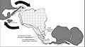 Paleogeography of the Late Cretaceous South America. Areas subject to the Andean orogeny are shown in light grey while the stable cratons are shown as grey squares. The sedimentary formations of Los Alamitos and La Colonia that formed in the Late Cretaceous are indicated. (from Andean orogeny)
 -

-
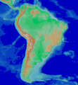 Map of the Andean region of South America (from Andean agriculture)
 -

-
 The seaward tilting of the sedimentary strata of Salto del Fraile Formation in Peru was caused by the Andean orogeny. (from Andean orogeny)
 -

-
 Bolivian Andes (from Andes)
 -
 Aerial view of Valle Carbajal in the Tierra del Fuego. The Andes range is about 200 km (124 mi) wide throughout its length, except in the Bolivian flexure where it is about 640 kilometres (398 mi) wide. (from Andes)
 -
-
 Syncline next to Nordenskjöld Lake in Torres del Paine National Park. The syncline formed during the Andean orogeny. (from Andean orogeny)
 -
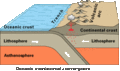 Simplified sketch of the present-situation along most of the Andes (from Andean orogeny)
 -
 Frederic Edwin Church, Heart of the Andes, 1859. (from Andes)
 -

-
 Mashua tubers (from Andean agriculture)
 -
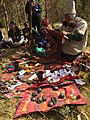 Pacha Mama Ceremony (from Andean agriculture)
 -
-
 Pico Humboldt at sunset (from Andes)
 -
 Laguna de Sonso tropical dry forest in Northern Andes (from Andes)
 -
 A male Andean cock-of-the-rock, a species found in humid Andean forests and the national bird of Peru (from Andes)
 -
 Topographic map of the Andes by the NASA. The southern and northern ends of the Andes are not shown. The Bolivian Orocline is visible as a bend in the coastline and the Andes lower half of the map. (from Andean orogeny)
 -
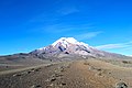
 Parinacota, Bolivia/Chile (from Andes)
 -
 Irrigating land in the Peruvian Andes (from Andes)
 -

-
 View of Cuernos del Paine in Torres del Paine National Park, Chile (from Andes)
 -

-

-
 Central Andes (from Andes)
 -

-
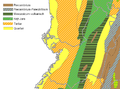 Map of a north-south sea-parallel pattern of rock ages in western Colombia. This pattern is a result of the Andean orogeny. (from Andean orogeny)
 -
 Ulluco: Common crop of the Andean region (from Andean agriculture)
 -
 Peruvian farmers sowing maize and beans (from Andes)
 -
 Nevado del Huila, Colombia (from Andes)


.jpg)


%E2%80%93Valle_Carbajal_01.jpg)


.JPG)


.jpg)


.jpg)

.jpg)
Subcategories

- Select [►] to view subcategories
Related portals
Subtopics
Associated Wikimedia
The following Wikimedia Foundation sister projects provide more on this subject:
-
 Commons
Free media repository -
 Wikibooks
Free textbooks and manuals -
 Wikidata
Free knowledge base -
 Wikinews
Free-content news -
 Wikiquote
Collection of quotations -
 Wikisource
Free-content library -
 Wikiversity
Free learning tools -
 Wiktionary
Dictionary and thesaurus


