
Portal:Myanmar
ကြိုဆိုပါတယ်။ / Welcome to the Myanmar Portal 

Myanmar, officially the Republic of the Union of Myanmar and also known as Burma (the official name until 1989), is a country in Southeast Asia. It is the largest country by area in Mainland Southeast Asia and has a population of about 55 million. It is bordered by Bangladesh and India to its northwest, China to its northeast, Laos and Thailand to its east and southeast, and the Andaman Sea and the Bay of Bengal to its south and southwest. The country's capital city is Naypyidaw, and its largest city is Yangon (formerly Rangoon).
Myanmar is a member of the East Asia Summit, Non-Aligned Movement, ASEAN, and BIMSTEC, but it is not a member of the Commonwealth of Nations despite once being part of the British Empire. Myanmar is a Dialogue Partner of the Shanghai Cooperation Organization. The country is very rich in natural resources, such as jade, gems, oil, natural gas, teak and other minerals, as well as also endowed with renewable energy, having the highest solar power potential compared to other countries of the Great Mekong Subregion. However, Myanmar has long suffered from instability, factional violence, corruption, poor infrastructure, as well as a long history of colonial exploitation with little regard to human development. In 2013, its GDP (nominal) stood at US$56.7 billion and its GDP (PPP) at US$221.5 billion. The income gap in Myanmar is among the widest in the world, as a large proportion of the economy is controlled by cronies of the military junta. Myanmar is one of the least developed countries; as of 2020, according to the Human Development Index, it ranks 147 out of 189 countries in terms of human development, the lowest in Southeast Asia. Since 2021, more than 600,000 people were displaced across Myanmar due to the surge in violence post-coup, with more than 3 million people in dire need of humanitarian assistance. (Full article...)
Selected articles -
-

Insurgencies have been ongoing in Myanmar since 1948, the year the country, then known as Burma, gained independence from the United Kingdom. The conflict has largely been ethnic-based, with several ethnic armed groups fighting Myanmar's armed forces, the Tatmadaw, for self-determination. Despite numerous ceasefires and the creation of autonomous self-administered zones in 2008, many armed groups continue to call for independence, increased autonomy, or the federalisation of the country. The conflict is the world's longest ongoing civil war, having spanned more than seven decades. (Full article...) -

Shan State (Shan: မိူင်းတႆး, Möng Tai; Burmese: ရှမ်းပြည်နယ်, pronounced [ʃáɰ̃ pjìnɛ̀]) is a state of Myanmar. Shan State borders China (Yunnan) to the north, Laos (Louang Namtha and Bokeo Provinces) to the east, and Thailand (Chiang Rai, Chiang Mai and Mae Hong Son Provinces) to the south, and five administrative divisions of Myanmar in the west. The largest of the 14 administrative divisions by land area, Shan State covers 155,800 km2, almost a quarter of the total area of Myanmar. The state gets its name from Burmese name for the Tai peoples: "Shan people". The Tai (Shan) constitute the majority among several ethnic groups that inhabit the area. Shanland is largely rural, with only three cities of significant size: Lashio, Kengtung, and the capital, Taunggyi. Taunggyi is 150.7 km northeast of the nation's capital Naypyitaw.
The Shan state, with many ethnic groups, is home to several armed ethnic groups. While the military government has signed ceasefire agreements with most groups, vast areas of the state, especially those east of the Salween River, remain outside the central government's control, and in recent years have come under heavy ethnic-Han Chinese economic and political influence. Other areas are under the control of military groups such as the Shan State Army. (Full article...) -
The Myanmar Air Force (Burmese: တပ်မတော် (လေ), pronounced [taʔmədɔ̀ (le)]), known until 1989 as the Burmese Air Force, is the aerial branch of Myanmar's armed forces, the Tatmadaw. The primary mission of the Myanmar Air Force (MAF) since its inception has been to provide transport, logistical, and close air support to the Myanmar Army in counter-insurgency operations. It is mainly used in internal conflicts in Myanmar, and, on a smaller scale, in relief missions, especially after the deadly Cyclone Nargis of May 2008. (Full article...) -
Myint Myint Khin FRCP (Burmese: မြင့်မြင့်ခင်, pronounced [mjɪ̰ɰ̃ mjɪ̰ɰ̃ kʰɪ̀ɰ̃]; 15 December 1923 – 19 June 2014) was a Burmese medical professor and writer. An English major at the University of Rangoon, she was the chair of the Department of Medicine of the Institute of Medicine, Mandalay from 1965 to 1984, and served as a consultant at the World Health Organization from 1985 to 1991. Her literary career began in 1996, spurred on by the HIV/AIDS crisis in the country. She published 11 books in Burmese and two in English. At the time of her death, the former professor was collaborating on an English language book on the history of medical education in the country.
Most of her books dealt with public health and medicine. One notable exception was her last published book in 2013, Poetry for Me, a collection of her English language poetry, which she began working on after the death of her husband Dr. San Baw, a hip replacement pioneer, in 1984. Through her books and interviews, she advocated for more openness and transparency in the country, and spoke out about the regression of women's rights in Myanmar. In 2012, she founded a daycare center for elderly physicians in Yangon. (Full article...) -
Mandalay International Airport (IATA: MDL, ICAO: VYMD), located 35 km south of Mandalay in Tada-U, is one of three international airports in Myanmar. Completed in 1999, it replaced the old Mandalay Chanmyathazi Airport as the city's main airport and it was the largest and most modern airport in the country until the modernization of Yangon International Airport in 2008. The airport connects 11 domestic and seven international destinations. Its 4,267 m (13,999 ft) runway is the longest runway in use in Southeast Asia and has the capacity to handle up to 3 million passengers a year. (Full article...) -

Mandalay (/ˌmændəˈleɪ/ or /ˈmændəleɪ/; Burmese: မန္တလေး; MLCTS: manta.le: [mándəlé]) is the second-largest city in Myanmar, after Yangon. Located on the east bank of the Irrawaddy River, 631 km (392 miles; road distance) north of Yangon, the city has a population of 1,225,553 (2014 census).
Mandalay was founded in 1857 by King Mindon, replacing Amarapura as the new royal capital of the Konbaung dynasty. It was Burma's final royal capital before the kingdom's annexation by the British Empire in 1885. Under British rule, Mandalay remained commercially and culturally important despite the rise of Yangon, the new capital of British Burma. The city suffered extensive destruction during the Japanese conquest of Burma in the Second World War. In 1948, Mandalay became part of the newly independent Union of Burma. (Full article...) -
The 2010–2012 Myanmar border clashes were a series of skirmishes between the Tatmadaw (Myanmar Armed Forces) on one side, and the DKBA-5 and the Karen National Liberation Army (KNLA) on the other. The clashes erupted along the border with Thailand shortly after Myanmar's general election on 7 November 2010. An estimated 10,000 refugees have fled into nearby neighbouring Thailand to escape the violent conflict. There was concern that due to discontent with the elections, and speculations of electoral fraud, that the conflict could escalate into a civil war. (Full article...)
-
Naypyidaw, officially romanized Nay Pyi Taw (Burmese: နေပြည်တော်; MLCTS: Nepranytau; pronounced [nèpjìdɔ̀] lit. 'Grand Capital'), is the capital and third-largest city of Myanmar. The city is located at the centre of the Naypyidaw Union Territory. It is unusual among Myanmar's cities in that it is an entirely planned city outside of any state or region. The city, then known only as Pyinmana District, officially replaced Yangon as the administrative capital of Myanmar on 6 November 2005; its official name was revealed to the public on Armed Forces Day, 27 March 2006.
As the seat of the government of Myanmar, Naypyidaw is the site of the Union Parliament, the Supreme Court, the Presidential Palace, the official residences of the Cabinet of Myanmar and the headquarters of government ministries and military. Naypyidaw is notable for its unusual combination of large size and very low population density. The city hosted the 24th and 25th ASEAN Summit, the 3rd BIMSTEC Summit, the Ninth East Asia Summit, the 2013 Southeast Asian Games and the 2014 AFC U-19 Championship. (Full article...) -
On 2 July 2020, a major landslide at the Wai Khar jade mining site in the Hpakant area of Kachin State, Myanmar, killed between 175 and 200 miners in the country's deadliest-ever mining accident. At 06:30 local time (MMT) heavy rains triggered the collapse of a heap of mining waste, which came tumbling down into a lake. This generated a 6.1-meter (20 ft) wave of mud and water that buried those working at the Wai Khar mine. The miners killed or injured by the landslide were independent "jade pickers", who scavenge tailings from larger operators and who live in ramshackle quarters at the base of large mounds of rubble.
Myanmar's jade industry supplies 70% to 90% of the world jade supply. The industry had become known for its fatal accidents in the preceding years, with the previous deadliest accident in 2015 killing 116 people. While the government responded with promises to make reforms in the jade mining industry, activists claim that little has been done in practice since then. (Full article...) -
The Burma Railway, also known as the Siam–Burma Railway, Thai–Burma Railway and similar names, or as the Death Railway, is a 415 km (258 mi) railway between Ban Pong, Thailand, and Thanbyuzayat, Burma (now called Myanmar). It was built from 1940 to 1943 by South East Asian civilians abducted and forced to work by the Japanese and a smaller group of captured Allied soldiers, to supply troops and weapons in the Burma campaign of World War II. It completed the rail link between Bangkok, Thailand, and Rangoon, Burma. The name used by the Japanese Government was Tai–Men Rensetsu Tetsudō (泰緬連接鉄道), which means Thailand-Burma-Link-Railway.
At least 250,000 Southeast Asian civilians were subjected to forced labour to ensure the construction of the Death Railway and more than 90,000 civilians died building it, as did around 12,000 Allied soldiers. The workers on the Thai side of the railway were Tamils, Malays, and fewer Chinese civilians from Malaya. Possibly over 345,000 died while working, with the death rate per month rivaling that of Auschwitz. (Full article...)


Did you know (auto-generated) -

- ... that the Burmese and South Korean first ladies held their first informal conversation 44 years after the establishment of bilateral relations between the two countries?
- ... that clashes between the Myanmar military and local armed groups broke out in Lay Kay Kaw six years after it was established as a "town of peace" between the parties?
- ... that Thinzar Shunlei Yi hid in the Burmese jungle for a month and joined a rebel militia following the 2021 Myanmar coup d'état?
- ... that one academic described the introduction of femboys to Myanmar as a tactic to achieve an "ideological revolution"?
- ... that squatters in Myanmar were punished for protesting against the 2021 coup d'état by being evicted?
- ... that Esther Ze Naw, who appeared on the 2021 Time 100, was one of the few people in Myanmar who protested against Aung San Suu Kyi's defence of the military at the International Court of Justice in December 2019?
- ... that Rolling Stone named Mission of Burma's "Academy Fight Song" as one of the 100 greatest debut singles of all time?
- ... that Rangoon kept its own time for more than two decades after Burma Standard Time first came into effect?
Related portals and projects
General images -
-
 The restored Taungoo or Nyaungyan dynasty c. 1650 CE. (from History of Myanmar)
 -

-
 A wedding procession, with the groom and bride dressed in traditional Burmese wedding clothes, reminiscent of royal attire (from Culture of Myanmar)
 -
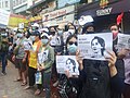 Protesters in Yangon carrying signs reading "Free Daw Aung San Suu Kyi" on 8 February 2021. (from History of Myanmar)
 -
 Two female musicians play the saung at a performance in Mandalay. (from Culture of Myanmar)
 -
 Grandfather Island, Dawei (from Geography of Myanmar)
 -
 Recorder's Court on Sule Pagoda Road, with the Sule Pagoda at the far end, Rangoon, 1868. Photographer: J. Jackson. (from History of Myanmar)
 -
 Myinhkin thabin - equestrian sport (from Culture of Myanmar)
 -
 Former US President Barack Obama poses barefoot on the grounds of Shwedagon Pagoda, one of Myanmar's major Buddhist pilgrimage sites. (from Culture of Myanmar)
 -
 The paddle steamer Ramapoora (right) of the British India Steam Navigation Company on the Rangoon river having just arrived from Moulmein. 1895. Photographers: Watts and Skeen (from History of Myanmar)
 -
 Protesters in Yangon with a banner that reads non-violence: national movement in Burmese, in the background is Shwedagon Pagoda. (from History of Myanmar)
 -
 The shores of Irrawaddy River at Nyaung-U, Bagan (from Geography of Myanmar)
 -
 British soldiers remove their shoes at the entrance of Shwedagon Pagoda. To the left, a sign reads "Foot wearing is strictly prohibited" in Burmese, English, Tamil, and Urdu. (from Culture of Myanmar)
 -
 A wide range of Burmese lacquerware from Bagan (from Culture of Myanmar)
 -
 Sculpture of Myanmar mythical lion (from Culture of Myanmar)
 -
 British soldiers on patrol in the ruins of the Burmese town of Bahe during the advance on Mandalay, January 1945. (from History of Myanmar)
 -
 Temples at Mrauk U, was the capital of the Mrauk U Kingdom, which ruled over what is now Rakhine State. (from History of Myanmar)
 -

-
 Salween river at Mae Sam Laep on the Thai-Myanmar border (from Geography of Myanmar)
 -
 Aerial view of a burned Rohingya village in Rakhine state, Myanmar, September 2017 (from History of Myanmar)
 -
 A bull fight, 19th-century watercolour (from Culture of Myanmar)
 -
 A large fracture on the Mingun Pahtodawgyi caused by the 1839 Ava earthquake. (from Geography of Myanmar)
 -
 British soldiers dismantling cannons belonging to King Thibaw's forces, Third Anglo-Burmese War, Ava, 27 November 1885. Photographer: Hooper, Willoughby Wallace (1837–1912). (from History of Myanmar)
 -
 Political Map of Burma (Myanmar) c. 1450 CE. (from History of Myanmar)
 -
 Hlei pyaingbwè - a Burmese regatta (from Culture of Myanmar)
 -
 Mountains near Pindaya on the Shan Plateau (from Geography of Myanmar)
 -
 Myanmar (Burma) map of Köppen climate classification (from Geography of Myanmar)
 -

-

-
 Jade Mine in Hpakant (from Geography of Myanmar)
 -
 Portuguese ruler and soldiers mounting an Elephant. Philips, Jan Caspar (draughtsman and engraver) (from History of Myanmar)
 -
 Mount Popa, a dormant volcano in the Central Lowlands (from Geography of Myanmar)
 -
 Vegetable stall on the roadside at the Madras Lancer Lines, Mandalay, January 1886. Photographer: Hooper, Willoughby Wallace (1837–1912). (from History of Myanmar)
 -
 Saint Mary's Cathedral in Downtown Yangon is the largest Roman Catholic cathedral in Burma. (from Culture of Myanmar)
 -
 Aung San Suu Kyi addresses crowds at the NLD headquarters shortly after her release. (from History of Myanmar)
 -
 Boxing match, 19th-century watercolour (from Culture of Myanmar)
 -
 19th-century funeral cart and spire, which would form part of the procession from the home to the place of cremation (from Culture of Myanmar)
 -
 Pagan Kingdom during Narapatisithu's reign. Burmese chronicles also claim Kengtung and Chiang Mai. Core areas shown in darker yellow. Peripheral areas in light yellow. Pagan incorporated key ports of Lower Burma into its core administration by the 13th century. (from History of Myanmar)
 -
 A group of Buddhist worshipers at Shwedagon Pagoda, an important religious site for Burmese Buddhists (from Culture of Myanmar)
 -
 A theatrical performance of the Mon dance (from Culture of Myanmar)


_headquarter.jpg)


Major topics
Categories

More topics

Associated Wikimedia
The following Wikimedia Foundation sister projects provide more on this subject:
-
 Commons
Free media repository -
 Wikibooks
Free textbooks and manuals -
 Wikidata
Free knowledge base -
 Wikinews
Free-content news -
 Wikiquote
Collection of quotations -
 Wikisource
Free-content library -
 Wikiversity
Free learning tools -
 Wikivoyage
Free travel guide -
 Wiktionary
Dictionary and thesaurus


